Urban expansion and its implications on prominent wetlands of National Capital Territory
-
Rivers and lakes
Wetlands have played a vital role in Delhi’s history. Delhi has been a fortress city since ancient times with an elaborate network of water management and distribution systems which included wells, tanks and water bodies. However, as any other mega city, Delhi has grown at an unprecedented and irreversible rate, which has severely strained the city’s natural resources and constricted its water supply. Delhi, the capital of India, the second-most populous city in the world demonstrates a classic example of unbridled urbanization. As spiraling population in the city and its demand for land increases, a tendency of encroaching on wetlands thrives.
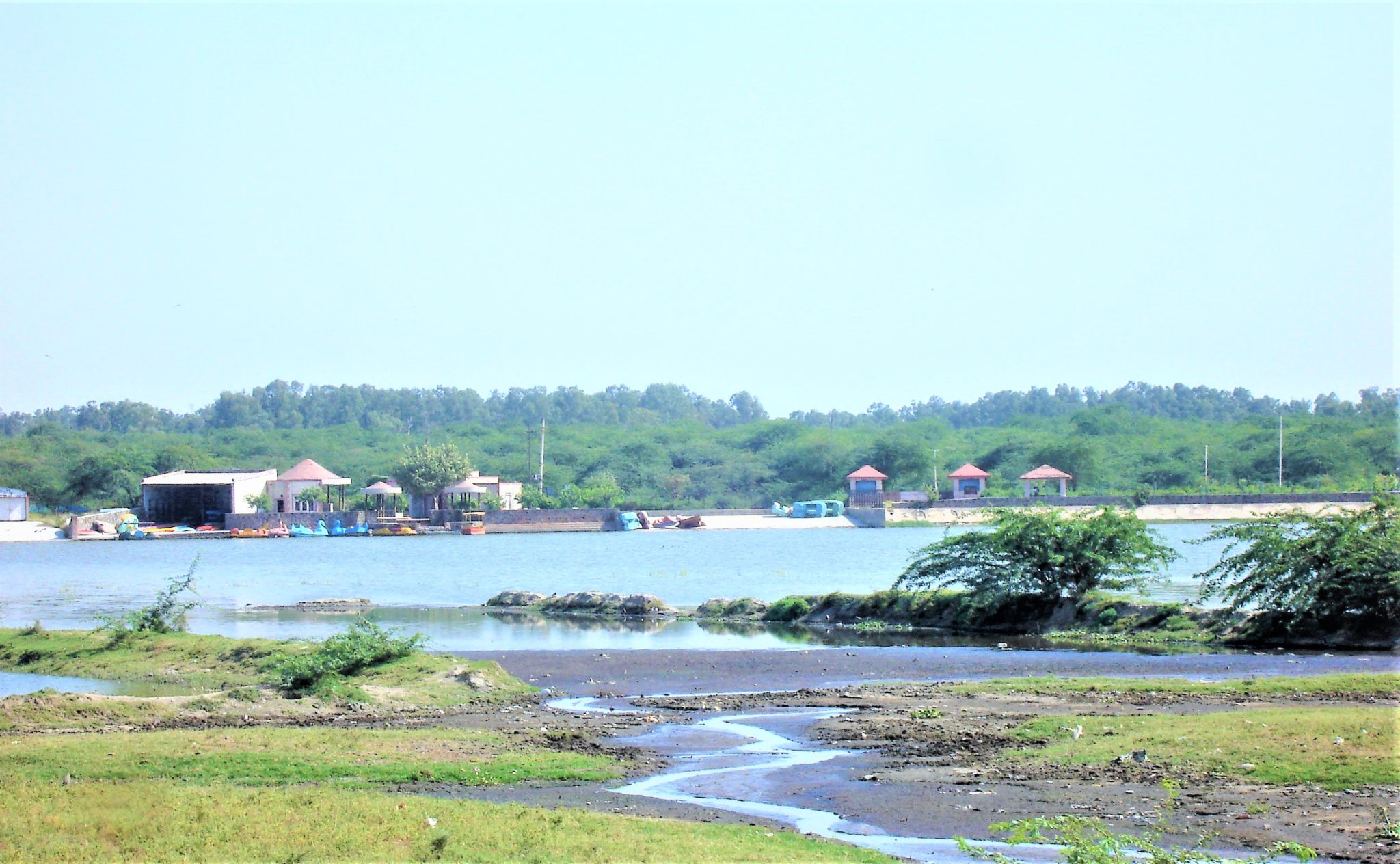
Persistent water crisis and changing climate (urban floods, water logging, rising temperatures) have once again brought to the fore importance of wetlands and their ecosystem services as a means to tackle these large-scale issues. Delhi’s Climate Action Plan in 2009 enlisted 621 wetlands to have existed of which majority have dried up and/or are beyond recovery, largely attributable to their encroached catchments and severed or blocked inlets1. Priority wetlands identified by Delhi government for conservation and management includes Bhalswa Lake, Sanjay Lake and Najafgarh lake that have been in a state of peril for long. These wetlands once provided abode to a large number of resident and migratory birds in addition to provisioning for freshwater and acting as excellent groundwater recharge zones along with regulating local climate within mega cities. Two of these wetlands, Bhalswa and Sanjay lake have been identified by the National Plan for Conservation of Aquatic ecosystems (NPCA) for immediate attention and interventions.
The present study aimed at analyzing the current state of these priority wetlands on a spatio-temporal scale using earth observation data for a period of three decades (1990 to 2020). Also, their ecological condition was assessed using water quality parameters as a proxy. Land Use Land Cover (LULC) changes were mapped in a 5 km buffer area which directly feed these lakes.
Over three decades, the extent of Najafgarh lake has suffered maximum loss of 46%, followed by Sanjay lake with a 35% shrinkage whereas Bhalswa has undergone 23% change in its extent compared to 1990. Rapid urbanization has been observed within the buffer zone of Bhalswa lake with an increase of 58% followed by an increase of 27% in the buffer zone of Sanjay lake. With nearly no built-up area surrounding Najafgarh lake in 1990, the region has urbanized extensively in the past three decades observing a growth of 6946 ha in built-up area. Urbanization has affected the inflows received by these wetlands thus having an impact on the wetland extent as well as wetlands condition. Temporal analysis of earth observation data further revealed that the natural vegetation cover has also been converted to built up along with the agricultural land.
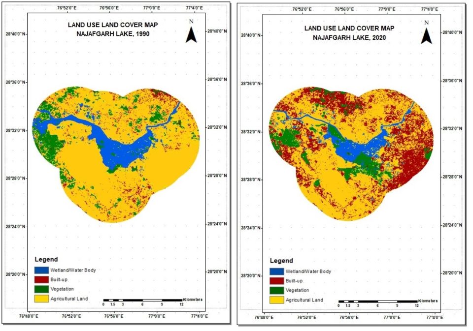 Map: 1

MAP: 2
Structural modifications within the wetlands buffer zone have immensely altered the physical regimes of these wetlands which has been documented by several other researchers. Major nonconformities have been observed in the wetland water quality. Domestic, agricultural and industrial waste waters received by Najafgarh lake have led to an unprecedented increase in chloride, nitrate and COD levels which far exceed the lake’s self-purification capacity2. Algal blooms have become recurrent within the waters of Bhalswa that are organically polluted with nutrient loading, garbage and solid waste from ever-expanding landfill in its immediate vicinity3. Pollution levels within Sanjay lake built by DDA also exceeds the water quality standards and is rendered unfit for consumption, irrigation and fish culture4.
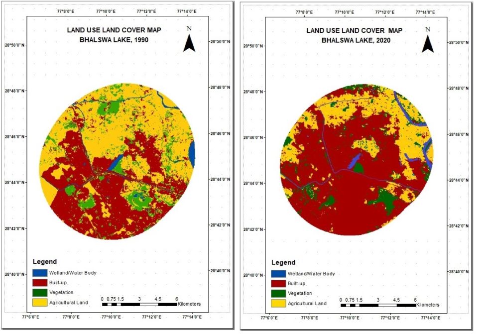
MAP: 3
Present study led to the identification of major drivers of change responsible for deteriorating health of these wetlands’ ecosystems leading to a potential of loss of ecosystem services. Results of this study can contribute to the development of sound integrated wetlands management plan to support the restoration and conservation of these wetlands. Moreover, a comprehensive wetland monitoring programme which relies on technological and scientific advancements such as utilization of easily accessible earth observation data can help implementation and prioritization of scientifically sound and informed decisions for management of these priority wetlands.
Maps 1-3: Spatio-temporal changes in the land use and land cover within the buffer zones of priority wetlands of Delhi from 1990-2020 1) Najafgarh Lake 2) Sanjay Lake and 3) Bhalaswa Lake
References:
1 Delhi Climate Action Plan, National Wetland Conservation Programme Guidelines for Conservation and Management of Wetlands In India Conservation and Survey Division Ministry of Environment and Forests Government of India New Delhi. (2009). Management, 1–45.
2 Nehra, V. (2018). Assessment of water quality of Najafgarh drain and its impact on river Yamuna. Department of environmental engineering.
3 Jindal, T. Emmanuel, M. A., (2018). Assessment of Biological Parameters of Sanjay Lake and Old Fort Lake Water in Delhi. 8(6), 44–48. https://doi.org/10.9790/9622-0806044448
4 Singh, S. K. (2017). Assessment of water quality parameters of Bhalswa Lake in New Delhi. International Journal of Environmental Engineering, 9(1), 52. https://doi.org/10.1504/ijee.2017.10008926
Author: Himadri Kaushik
Author is pursuing MSc (Natural Resource Management) from Guru Gobind Singh Indraprastha University, Delhi and is currently interning with Wetlands International South Asia.